Rome Travel Guide

Rome Architecture, History, Art, Museums, Galleries, Fashion, Music, Photos, Walking and Hiking Itineraries, Neighborhoods, News and Social Commentary, Politics, Things to Do in Rome and Environs. Over 900 posts

Showing posts with label aqueducts. Show all posts

Wednesday, August 31, 2022

The Mystery of the Crowing Rooster: A day in the Italian hill town of Gallicano nel Lazio


The photo above gives some idea of the hilltop nature of the town, and the curving roads.

Gallicano nel Lazio (i.e., in the province of Lazio, the same province as Rome - there's a Gallicano in Tuscany that has some history involving Puccini, but it's not this one) is one of those Italian hill towns (meaning they are situated smack dab on the hill, not just "in the hills") that have great appeal for us. Bill already posted on Facebook a bit about this town of 6,000 people, but we thought it deserved more attention than Facebook allows.

Our photo from 2014. We saw buses doing the same treacherous
turn this year.

It was Bill's pick for our almost-weekly trip out of Rome. I was delighted with his choice, because I thought we would pick our way among the fabulous aqueducts that lie below the town (more about those at the end of the post). But, no, he's "been there, done that," and so after 20 miles or so from Rome, we wound our way up the town's steep, curvy approach, deciding to bail out as tilting buildings and road curves lay above us. We parked at a new-ish gas station, perched on the side of the town's cliffs. (First we had to go through a gap in the tufo rock so narrow that it now has a light and one-way traffic at times, and we were astonished that a bus could pick its way through it - so astonished we didn't take photos - but we did find a photo from 2014, when we had the sense to take a picture - above).


The gas station that became our home base.
More on this photo at the end of the post.


When Bill asked the gas station (really the woman at the bar attached to it) if we could park there, she indicated we should park in a corner. We thought that rather silly, since the station didn't seem to be attracting customers. But we did as we were told and 'hiked' our way up to the town, finding a superimposed 'modern' staircase here and there to help us get to the top.


Dianne trying one of the vicoli.

The town had many of the small "streets" and alleys (vicoli) common for hill towns (we decided the Mediterranean diet isn't so much what they eat, but that they climb up and around all these hill towns!). 


What fascinated us about the town was its various monuments, and especially the town crest, which features a crowing rooster.  We think that's what Gallus-Canit means ("canit" perhaps related to "cantare" or singing). While the town seems named after a nobleman named Gallicano who was a friend of Constantine's, there's another story about the crowing rooster that's more evocative.


The town crest worked into the sampietrini or 
cobblestones (apologies for the car covering
the star, and Dianne's legs).


Legend has it... that one night, a group of soldiers, in the service of the enemy Rospigliosi family (aristocrats of Pistoia), tried to attack the town, taking advantage of the rest of the inhabitants. But a dog started barking at strangers. A rooster echoed him and with his insistent crow woke the population from sleep. The people armed themselves with spears, swords and everything that came within range, repelling the invaders. Since then the town, to give back to those who had, unwittingly, saved the town from occupation, took the name, by which it is still known today, of Gallicano.


.
The crest appears in many forms,
in many places in the town, including
  the parking area and this fountain.


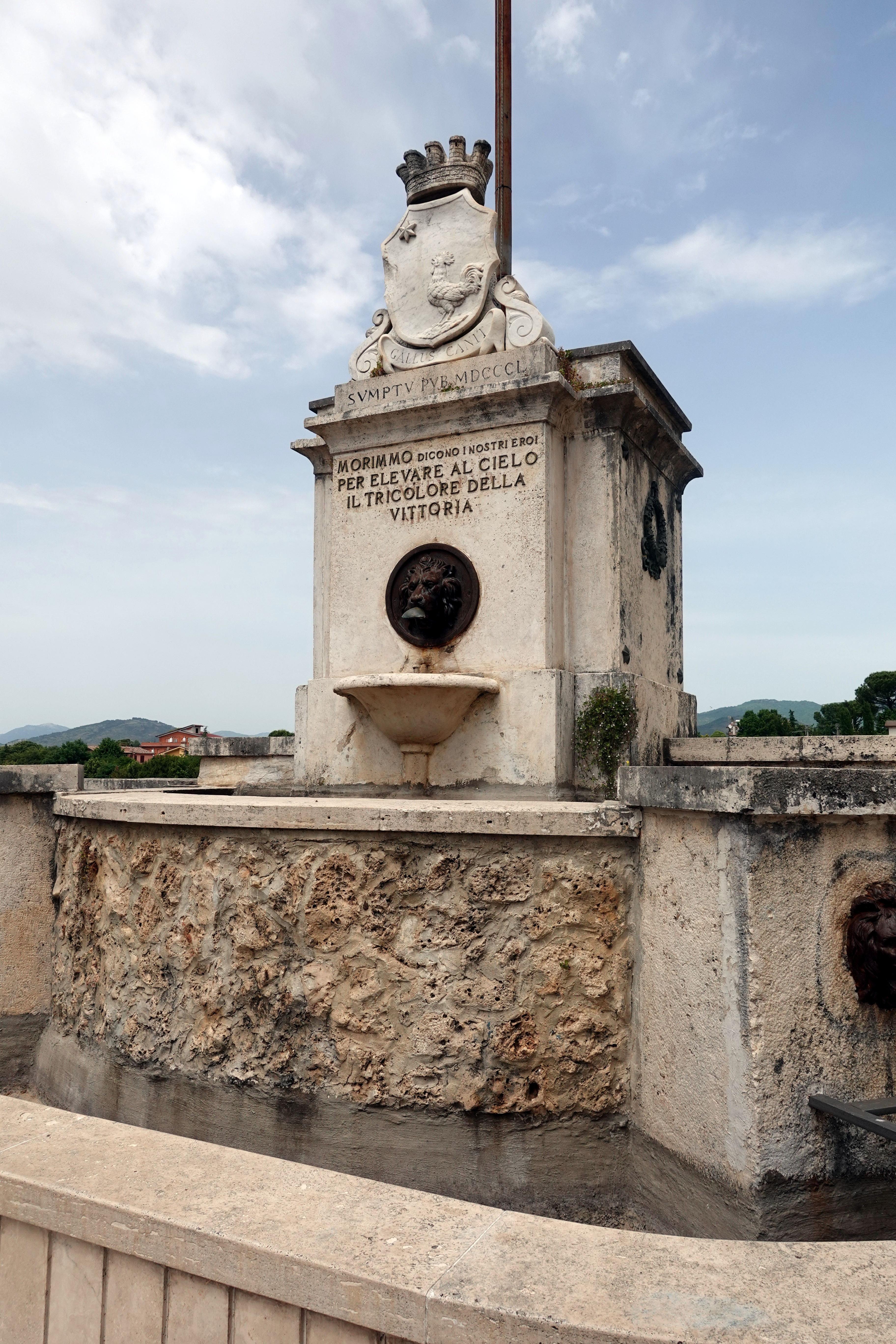
The town was full of monuments of all types. The one above right is a war memorial which has the crowing rooster crest at the top, and a reference to 1850 (maybe to the Risorgimento [Italy's effort to create a state and release itself from Papal and other control]?), and the words: "We died, say our heroes, so we could lift the tricolor [Italian flag] of victory to the skies [heavens]."

And, to show off it's not just about roosters and war, one of the town's parks had this bench, which, if you look at it from the side, is an open book:

The excerpt from Dante's Inferno, Canto 26, reads:
"Consider your origins. You were not made to live as brutes, but to follow virtue and knowledge."

A last monument is in the photo below. We found it while scouting the outskirts of the town.  Unfortunately, we don't have any more information on it. If someone does, let us know!


Close-ups reveal some interesting figures in the "windows" - women? immigrants? people in distress?


At the gas station, we found a good assortment of tramezzini (those crustless white bread sandwiches you wanted as kids - though they probably didn't come in funghi e spinaci [mushrooms and spinach]) and Coca Zero (apologies, but we can't celebrate the end of a hike with a beer when on the scooter). The people-watching there was good as well. The attendant was right - the gas station became the town center as people came and went after their 1-3 p.m. pranzo, buying milk, cigarettes, ice cream for their kids, lottery tickets, and gas. We enjoyed our front-row seat to the town's populace (Bill is at one of the tables on the left in the gas station photo above).

The railings to keep you from falling into the
stream below are now mostly gone.

Our final stop, at my insistence, was to get a glimpse of the wonderful aqueducts. Only this time, after 30 minutes one-way of walking, we found only one and then a blocked road.  We'll have to go back to find our "aqueduct trail" that we wrote about 8 years ago.


And, here's a photo from the 2014 aqueduct hike that should give you an incentive to try it (and us to go back)


Dianne


Tuesday, December 8, 2020

Castel San Pietro: of War Monuments and Movie Sites


In thinking about places we miss - and that are often missed period - my mind landed on Castel San Pietro, a small town above Palestrina. I planned to write that Palestrina (dating back farther than the 8th century BC) is one of the more important cities within 25 miles of Rome, but Wikipedia gives it short shrift. 


It gives even shorter shrift to Castel San Pietro, calling it "now occupied by a few poor houses and a ruined medieval castle of the Colonna family."  Whoa! Don't think the locals would like that description.  In fact, they worked hard to make Castel San Pietro a much-used movie site, especially in the 1950s, because of its picturesque setting. One can see Rome from its heights. Gina Lollobrigida starred in the 1953 "Bread, Love and Dreams" (Pane, Amore e Fantasia), filmed in the town. There are a dozen or so placards around  explaining the film sites in both Italian and English, though we've never seen a tourist of any nationality - or anyone speaking English.

We've always liked hiking up - and it's waaay up - to the "Rocca" or castle ruins (see photo at top) that form part of this small town above Palestrina. It's sort of (if you count going up and over the hill town when you don't have to) on our way to a hike we like that takes one down to ancient aqueducts - and Horace's tree - if we could ever find the latter.

What we found the last time we were wandering the town, looking for a coffee bar, were two war monuments, neither of which we'd seen in our previous walking around.


One monument was to the Italian combatants and Holocaust victims from the area who died in World War II, with this statue combining the two types of "caduti" - "fallen." Photo left.


The other monument, photo below, is accompanied by an inscription that reads, "In this place, on 6 July 1944, three young boys, playing with a war ordinance left over from the war, were made innocent victims. This monument is a testament to that incident, and stands against every war, past and present, against the shame of landmines and in honor of civilian victims. 8 December 2004." The Germans had left the area by early June, 1944

The two monuments together are a chilling testament to the horrors of war. And they make our casual escapade through the town, and down into the aqueducts, an after-thought. 

More later on the hike, which we do almost every year when we're in Rome, and Palestrina, home to the great 16th-century composer Giovanni Pierluigi da Palestrina, whose statue stands in a central town square, and to the fictional site where the pact with the devil was made in Thomas Mann's "Doctor Faustus." Mann spent some time in Palestrina in the late 1890s.

Dianne

Sunday, August 2, 2020

Roman roads pave the way to prosperity in the 21st century

The old via Prenestina, a Roman road we "ran across" in the Roman countryside,
this near Gallicano nel Lazio, during our mostly-successful search for aqueducts.

At RST we're fascinated by the new in Rome, and how it often ties into the old. We've also spent a fair amount of time in and outside of Rome, "discovering" ancient Roman roads, including one in the woods that we couldn't believe dated back two centuries (see photo at right).

Via Sacra ("Holy road") on Monte Cavo
on the way to what once was probably
a temple to the goddess Diana.


At its peak (second century CE), the Roman road system covered Europe and parts of the Middle East and Africa. The tie between the old Roman roads and contemporary life is the thesis of a recent study by Danish economists that links today's European centers of healthy economic activity with infrastructure created 2,000 years ago - the Roman road system.

Looking at the Roman roads in 117 CE, the four economists conclude "greater Roman road density goes along with (a) greater modern road density, (b) greater settlement formation in 500 CE, and (c) greater economic activity in 2010." Underscoring this conclusion is their finding that this tie is weakened to the point of insignificance "where the use of wheeled vehicles was abandoned from the first millennium CE until the late modern period" - that is, in the Middle East and North Africa.  They also found market towns flourishing from the medieval period to modern times along those Roman roads.

Ancient Roman roads (light yellow) superimposed on 2010 satellite imagery of nighttime lighting in Europe. (Washington Post illustration using data from NOAA Earth Observatory, Natural Earth and Digital Atlas of Roman and Medieval Civilization)

How did the economists figure this out?  Among other tools, they used contemporary population and road density and night-time satellite imagery of light. (See photo above.) The Danes piggybacked on Harvard University's research and mapping project - its Digital Atlas of Roman and Medieval Civilizations - which we plan to feature in a future post.

This article from the Washington Post, here, summarizes nicely the Danish research and has some illustrative maps.

The original paper is here:http://web.econ.ku.dk/pabloselaya/papers/RomanRoads.pdf

Talk about the need for infrastructure?  Could the US take a lesson here?

Dianne

Tuesday, December 19, 2017

Exploring the Valley of the Aniene, and Pietralata, on a Sunday afternoon

On a warm Sunday afternoon in late April, we took a walk through an area mostly new to us: the Riserva Naturale della Valle del Aniene (Nature Preserve of the Aniene Valley).  On most days the park would be empty, or virtually so, but on this sunny Sunday it was full of families and friends enjoying a variety of activities in the way Romans do.  We followed the path/park until we arrived at the rather forbidding Ponte Mammolo, where we crossed the Aniene before returning through Pietralata (eventually on busy, possibly dangerous via di Pietralata).  If I remember correctly, the walk took about 3 hours.  Below, some pics with brief commentary.


The walk begins at the very old Ponte Nomentana (parts of it dating possibly to the 8th century), which is reached on a brief spur that angles off the broad via Nomentana in the north of Rome. The bridge carried this consular road over the Aniene. The walk over the bridge begins Itinerary 10 in Rome the Second Time, but that itinerary heads left over the bridge.  On this day, we headed right. through this large gate, which  is just over the bridge.


We went through it and found ourselves on a broad path that more or less tracked the Aniene.


We found a large water channel, purpose and origin unknown.


In the distance on the left, a family had anchored their tent to a roll of hay that provided additional shade. 


Further on, playground equipment for the kids.


And a soccer game, for all ages, amid the weeds.


Bicycles--a good way to get into the park.


Picnicking.  The Italian word is "picnic," pronounced "peekneek"


Here, the door to a garden (no doubt "abusivo," illegal) is made from a mattress frame.


Walking on Ponte Mammolo, which crosses the Aniene.


Below, a large and elaborate garden--again, likely abusivo.


The Aniene below.  It's one of Rome's 2 rivers, even if unimpressive here.


Turning right and entering the neighborhoods (bring a map to make sure you don't lose your way at this point) on our return.  Note the striking stairway on this apartment building.


Below, a restaurant on via di Pietralata, closed between lunch and dinner. As we recall, this is the Pietralata "suburban" outpost of Betto e Mary, the original of which is in Torpignattara, near the Wunderkammern gallery.


Almost across the street from Betto e Mary is the arts center, l'ex Lanificio (the former wool factory), where in the past we saw exhibitions of art by Biodpi (Anna Magnani walking the she-wolf) and Alice (the painted trailer).  The center was quiet this day.


The Butcher Shop.  Meat cured or cooked.


Blue Chair. Poignant art photo.


Acqua Vergine (one of Rome's important aqueducts), water meter, 1868. Acqua Vergine's "show" fountain is the Trevi.  The aqueduct also runs under, and is accessible (with permission) via Villa Medici.


Almost back. Graffiti-covered courtyard of a business. 


All in all, not a thrill a minute, but a nice slice of Roman life. 
Bill

Tuesday, August 25, 2015

RST Top 40: # 17. Richard Meier's Suburban Jubilee Church


In these dog days of summer, we're taking the opportunity to re-post the following piece.  Originally posted in 2010, it is the most popular item we've ever published--some 15,000 page views. 


The Jubilee Church in suburban Rome is perhaps U.S. architect Richard Meier’s finest work. Not easy to get to using public transportation, but well worth the trek for those in Rome a second time, and therefore it hits our Top 40 list at #17. (See more on Meier in the links at the end of this post.)

Dives in Misericordia (“Rich in Mercy” – the church’s religious name, taken from Pope John Paul II’s second encyclical) is set in the Tor Tre Teste working class neighborhood of Rome, as that Pope wanted. And it is one of “50 churches for Rome” commissioned for the church’s Jubilee year (celebrating the 2,000th anniversary of Christ’s birth - jubilee years come every 50 years, but clearly 2,000 was a special one), although it was not completed until 2003. (See also Sartogo and Grenon's Santo Volto Church in Marconi.)

Meier’s church is in essence 3 enormous curved sail forms, a shape unusual for him. The sacred part of the church is marked by the wonderfully organic and curved spaces these sails produce, while in the administrative part Meier returns to more familiar rectangular shapes, that we see, for example, in his Getty Center in Los Angeles.

Modern materials are a hallmark of this church project, including a coated cement that is self-cleaning, which was a delight for the white-obsessed Meier. Meier won the competition for the church over 5 other internationally famous architects, including Frank Gehry, Peter Eisenman and Santiago Calatrava. Meier’s church is a testament to the Vatican’s good judgment, we think. See the New York Times' review of the church's consecrration: http://www.nytimes.com/2003/10/30/arts/vatican-s-modernist-moment-church-designed-richard-meier-consecrated-rome.html


We’ve also put directions on getting to the church via public transport at the end of this post.

The Vatican and Meier have been criticized for placing this modernist monument in a working class neighborhood, and basically cramming it into a space enclosed on 3 sides by unattractive apartment buildings and shops. But clearly this is what the Pope had in mind – lifting the neighborhood. As Meier recently said in response to questions about controversy over his works in Rome, “in Italy… unlike in [the U.S.]…architecture and politics are so intertwined.”

We think a trip to the Tor Tre Teste neighborhood is enlightening in many ways. You’ll see how ordinary Romans live. You’ll see magnificent architecture soaring in the midst of the commonplace – what could be more representative of Rome? If you walk a few yards from the church, you’ll also be able to amble through a park with a preserved ancient aqueduct – again, very Roman.

Meier’s other building in Rome is the “museum” and display of the 9th century BC Ara Pacis, the Roman altar to peace (“pacis”) - in this case meaning Roman conquest. It was the subject of even more controversy when it opened in 2006 (and there's still controversy - see Bill's post on a tunnel to be built along the Tevere next to the Ara Pacis). The right-wing picketed (we were there to cross the lines); the new right-wing mayor Alemanno called for Meier’s building to be torn down (or moved to the suburbs). Like everything else in Rome, these nutsy ideas, while stoking the culture wars ($24 million! To an American! It’s just a white box! It’s for the elite!), are now little more than vapors in the air. We didn’t put the Ara Pacis on our RST Top 40 list because it belongs on the First Time list – it’s the 3rd most visited site in Rome.

Dianne
Follow Rome the Second Time on FaceBook!  Click on the icon on the right.

(For more on Meier, see Bill's post on Rome's "Starchitects", Piazzo Augusto Imperatore, where the Ars Pacis is located - which comes in at No. 9 on RST's Top 40, and further afield the Rome/Michael Graves connection..  Generally for architectural comparisons of the highest order in Rome, see our recent post on MAXXI versus MACRO.)

Transportation:
Best option: get a friend to drive you;

second, take a taxi (but it will be very costly);

third - public transport as follows:
In back (on the South side; right as you're facing the terminal) of the main train station in Rome (Stazione Termini) is a commuter train line. You can take Bus 105 or 105L from the front of Termini to this place (3 stops) - or just ask and walk the several blocks back there. Then take the "train" labelled GARDINETT (for Gardinetti) 16 stops - the stop you want is "Tobagi"; the train runs every 5 minutes in normal hours. Walk about 50 yards to the bus stop "Tobagi" and catch Bus 556 (Gardenie) for 12 stops (to Tovaglieri/Ermoli); the 12 stops aren't that long, really just winding through the suburban high rises. The bus runs every 15 minutes. When you get off, you're 100 yards from the church and you should be able to see it or find it by asking for the church.

TO RETURN: Go back to where you got Bus 556 and take it again, going in the same direction you had been to arrive (Gardenie) - not back; take it 11 stops to Togliatti/Molfetta; go to the Tram stop Togliatti (this is a real tram) and take Tram 14 back to Termini.
Caveat: we have not taken public transportation; I'm relying on the City's transportation site for these directions. Don't ask me why the ways to/from are different. If you're a walker, you could walk to/from the Train or to/from the Tram and not have to go to and from different ways. Just a suggestion. Good luck on this!

Sunday, June 29, 2014

EUR: the Church of Saints Peter and Paul


In our new book, Modern Rome: 4 Great Walks for the Curious Traveler, one of the "great" walks is in EUR, the mid-century model city/suburb to the south of Rome's center.  But we had never been inside EUR's signature church, a structure sited prominently on the area's western hill and one visible from the trains that ply the airport route and from a variety of places in Rome proper.  Had we missed something?  Should we have included the Church of Saints Peter and Paul on our EUR excursion?

Evoking the aqueducts
No, and no.  Without a doubt, the church is beautifully sited.  A prominent, tree-lined street of shops and cafés leads directly into an enormous, broad flight of shallow travertine stairs, each decorated with geometric inlays: the circle, the square, the diamond.  At the top of the stairs, at the intersection with the piazza that fronts the church, enormous statues of Peter (on the left with keys), Paul (on the right with a sword), look out over EUR and, beyond it, onto the Alban Hills--a view unfortunately--and unnecessarily--disrupted by a multi-story post office building.  To the left and right of the church run concrete constructions that evoke the ancient aqueducts.  So far so good.


Spectacular view, but who authorized the post office, right?


Front door panels, from inside 
A second set of stairs (on the day we visited, a photographer was taking cheese-cake photos of a fashion model, much to the delight of 3 boys observing nearby) leads up to the church, whose entrance is dominated by colorful stained-glass panels--nice, if not elegant, from the inside. 


Suspended "crown" 

The interior of the church is interesting, but ultimately disappointing.  The design plan was based on Michelangelo's original idea for St. Peter's--a Greek cross.  Its essential roundness is emphasized by a suspended circle of lights--a sort of elevated crown--over the nave.  And the dome, referencing the Pantheon, is high, graceful, and impressive.  Even so, the height of the dome (at 72 meters, the 3rd highest in Rome) alone cannot yield the grandeur or power of the Pantheon, and the effort at roundness--so magical in Santo Stefano Rotondo--is checked on all sides by short, squared-off areas for the entrance, the chapels, and the apse.

Side chapel, with mosaics

Mosaics decorate the side chapels, but neither they, nor the bas relief stations of the cross, have
the refinement or quality to rescue the edifice from ordinariness.  At bottom, the building's failure to produce the sense of "awe" that all good churches have stems from its structure and size: a small structure, neither round nor square--a bit of both, in fatal compromise--with only height to evoke the infinite. 


Work on the Church of Saints Peter and Paul was begun in 1939 and completed in 1954.  It became a parish church in 1958.  It was designed by an architectural team; six architects are mentioned in some sources, and three prominently: Arnaldo Foschini, Tullio Russi, and Alfredo Energici.  Too many cooks, perhaps. 
Bill


Fashion shoot in progress on church steps