Rome Travel Guide

Rome Architecture, History, Art, Museums, Galleries, Fashion, Music, Photos, Walking and Hiking Itineraries, Neighborhoods, News and Social Commentary, Politics, Things to Do in Rome and Environs. Over 900 posts

Showing posts with label Gallicano nel Lazio. Show all posts

Wednesday, August 31, 2022

The Mystery of the Crowing Rooster: A day in the Italian hill town of Gallicano nel Lazio


The photo above gives some idea of the hilltop nature of the town, and the curving roads.

Gallicano nel Lazio (i.e., in the province of Lazio, the same province as Rome - there's a Gallicano in Tuscany that has some history involving Puccini, but it's not this one) is one of those Italian hill towns (meaning they are situated smack dab on the hill, not just "in the hills") that have great appeal for us. Bill already posted on Facebook a bit about this town of 6,000 people, but we thought it deserved more attention than Facebook allows.

Our photo from 2014. We saw buses doing the same treacherous
turn this year.

It was Bill's pick for our almost-weekly trip out of Rome. I was delighted with his choice, because I thought we would pick our way among the fabulous aqueducts that lie below the town (more about those at the end of the post). But, no, he's "been there, done that," and so after 20 miles or so from Rome, we wound our way up the town's steep, curvy approach, deciding to bail out as tilting buildings and road curves lay above us. We parked at a new-ish gas station, perched on the side of the town's cliffs. (First we had to go through a gap in the tufo rock so narrow that it now has a light and one-way traffic at times, and we were astonished that a bus could pick its way through it - so astonished we didn't take photos - but we did find a photo from 2014, when we had the sense to take a picture - above).


The gas station that became our home base.
More on this photo at the end of the post.


When Bill asked the gas station (really the woman at the bar attached to it) if we could park there, she indicated we should park in a corner. We thought that rather silly, since the station didn't seem to be attracting customers. But we did as we were told and 'hiked' our way up to the town, finding a superimposed 'modern' staircase here and there to help us get to the top.


Dianne trying one of the vicoli.

The town had many of the small "streets" and alleys (vicoli) common for hill towns (we decided the Mediterranean diet isn't so much what they eat, but that they climb up and around all these hill towns!). 


What fascinated us about the town was its various monuments, and especially the town crest, which features a crowing rooster.  We think that's what Gallus-Canit means ("canit" perhaps related to "cantare" or singing). While the town seems named after a nobleman named Gallicano who was a friend of Constantine's, there's another story about the crowing rooster that's more evocative.


The town crest worked into the sampietrini or 
cobblestones (apologies for the car covering
the star, and Dianne's legs).


Legend has it... that one night, a group of soldiers, in the service of the enemy Rospigliosi family (aristocrats of Pistoia), tried to attack the town, taking advantage of the rest of the inhabitants. But a dog started barking at strangers. A rooster echoed him and with his insistent crow woke the population from sleep. The people armed themselves with spears, swords and everything that came within range, repelling the invaders. Since then the town, to give back to those who had, unwittingly, saved the town from occupation, took the name, by which it is still known today, of Gallicano.


.
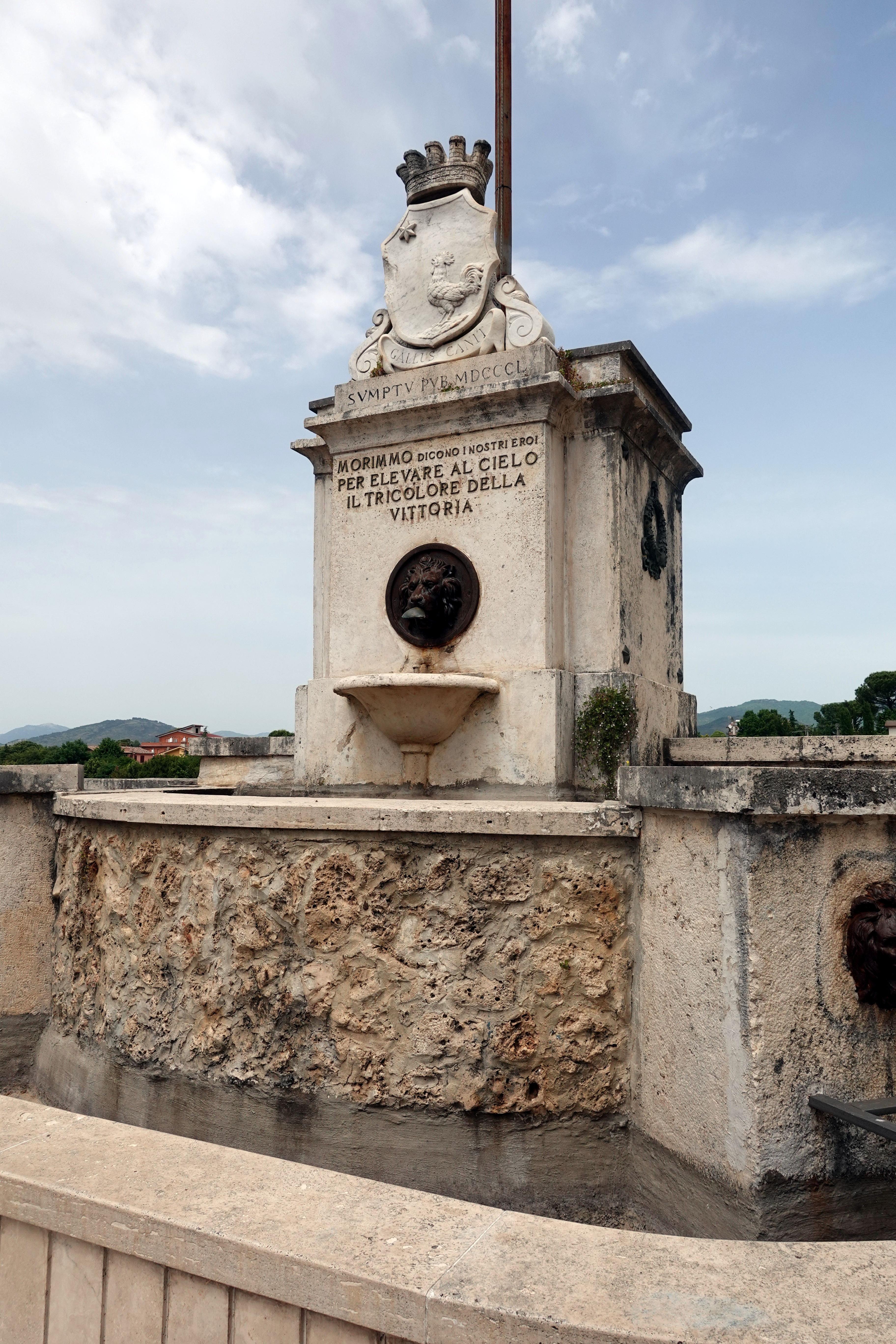
The crest appears in many forms,
in many places in the town, including
  the parking area and this fountain.


The town was full of monuments of all types. The one above right is a war memorial which has the crowing rooster crest at the top, and a reference to 1850 (maybe to the Risorgimento [Italy's effort to create a state and release itself from Papal and other control]?), and the words: "We died, say our heroes, so we could lift the tricolor [Italian flag] of victory to the skies [heavens]."

And, to show off it's not just about roosters and war, one of the town's parks had this bench, which, if you look at it from the side, is an open book:

The excerpt from Dante's Inferno, Canto 26, reads:
"Consider your origins. You were not made to live as brutes, but to follow virtue and knowledge."

A last monument is in the photo below. We found it while scouting the outskirts of the town.  Unfortunately, we don't have any more information on it. If someone does, let us know!


Close-ups reveal some interesting figures in the "windows" - women? immigrants? people in distress?


At the gas station, we found a good assortment of tramezzini (those crustless white bread sandwiches you wanted as kids - though they probably didn't come in funghi e spinaci [mushrooms and spinach]) and Coca Zero (apologies, but we can't celebrate the end of a hike with a beer when on the scooter). The people-watching there was good as well. The attendant was right - the gas station became the town center as people came and went after their 1-3 p.m. pranzo, buying milk, cigarettes, ice cream for their kids, lottery tickets, and gas. We enjoyed our front-row seat to the town's populace (Bill is at one of the tables on the left in the gas station photo above).

The railings to keep you from falling into the
stream below are now mostly gone.

Our final stop, at my insistence, was to get a glimpse of the wonderful aqueducts. Only this time, after 30 minutes one-way of walking, we found only one and then a blocked road.  We'll have to go back to find our "aqueduct trail" that we wrote about 8 years ago.


And, here's a photo from the 2014 aqueduct hike that should give you an incentive to try it (and us to go back)


Dianne


Sunday, August 2, 2020

Roman roads pave the way to prosperity in the 21st century

The old via Prenestina, a Roman road we "ran across" in the Roman countryside,
this near Gallicano nel Lazio, during our mostly-successful search for aqueducts.

At RST we're fascinated by the new in Rome, and how it often ties into the old. We've also spent a fair amount of time in and outside of Rome, "discovering" ancient Roman roads, including one in the woods that we couldn't believe dated back two centuries (see photo at right).

Via Sacra ("Holy road") on Monte Cavo
on the way to what once was probably
a temple to the goddess Diana.


At its peak (second century CE), the Roman road system covered Europe and parts of the Middle East and Africa. The tie between the old Roman roads and contemporary life is the thesis of a recent study by Danish economists that links today's European centers of healthy economic activity with infrastructure created 2,000 years ago - the Roman road system.

Looking at the Roman roads in 117 CE, the four economists conclude "greater Roman road density goes along with (a) greater modern road density, (b) greater settlement formation in 500 CE, and (c) greater economic activity in 2010." Underscoring this conclusion is their finding that this tie is weakened to the point of insignificance "where the use of wheeled vehicles was abandoned from the first millennium CE until the late modern period" - that is, in the Middle East and North Africa.  They also found market towns flourishing from the medieval period to modern times along those Roman roads.

Ancient Roman roads (light yellow) superimposed on 2010 satellite imagery of nighttime lighting in Europe. (Washington Post illustration using data from NOAA Earth Observatory, Natural Earth and Digital Atlas of Roman and Medieval Civilization)

How did the economists figure this out?  Among other tools, they used contemporary population and road density and night-time satellite imagery of light. (See photo above.) The Danes piggybacked on Harvard University's research and mapping project - its Digital Atlas of Roman and Medieval Civilizations - which we plan to feature in a future post.

This article from the Washington Post, here, summarizes nicely the Danish research and has some illustrative maps.

The original paper is here:http://web.econ.ku.dk/pabloselaya/papers/RomanRoads.pdf

Talk about the need for infrastructure?  Could the US take a lesson here?

Dianne

Tuesday, June 24, 2014

Aqueduct Hunting 101

First step in the aqueduct hunt:  waiting for the bus to get around the corner of
the tagliata  [the "cut" in the tufo]  - a car driver finally got out and directed traffic.
Aqueducts are the imposing reminders of Rome's thousands of years of history, and we're as intrigued as anyone by them.  So when we saw a map that purported to show "The Roman aqueducts itinerary," we were ready to go.  We assumed we'd be tromping through weeds that grow up among the high aqueducts, as one does at the Parco degli acquedotti [Aqueduct Park], not far from the center of Rome.

Yes, we thought this map would get us there.
Oh, well.
What we thought we'd find - these are at Parco degli Acquedotti,
number 2 on our RST Top 40 list.
We were a bit perplexed when we did not see any of these high aqueducts, as one often does, as we scootered ten, then twenty and more kilometers out of Rome on the via Prenestina, the road that led ancient Romans to Palestrina, almost to the current town of Gallicano nel Lazio. We dutifully followed the guide that told us we would go through and out of the darkness of something called the "Tagliata [cut] di Santa Maria di Cavamonte."  And a "cut" through the high tufo rock it was, as we waited for a bus, stuck in trying to make a curve through the dark tagliata [a word that until then meant for us a nice cut of steak].


The first or second century AD bridge on the ancient Roman road
to Palestrina - Ponte Amata.  Not an aqueduct, but our starting point.
Beyond the Tagliata we found our starting point, Ponte Amata, a first or second century A.D. bridge over the fosso [deep gully] in pristine condition, restored after being damaged in World War II, but now beginning to be surrounded again by the high grasses and weeds.  The ponte's dating is not certain, but is based on the Ponte di Nona, not too far away also on the ancient via Prenestina [at its ninth Roman mile from Rome] - and about which we've also written on the blog.

Dianne on the ancient via Prenestina, just before Ponte Amata.
Ponte Amata is just off the road, having been on the original via Prenestina, and it wasn't far along the road that we found good signposts indicating our route - or something close to it.


We trudged down a road, that became increasingly sterrata - or unpaved, until we came to another signpost - indicating our aqueduct was - to our surprise - far below where we were walking.

Our first aqueduct siting:  Ponte della Bullica. Dianne's red jacket
is visible where she's standing on the aqueduct bridge, about 50 feet above the
bottom of the fosso.
We followed the path down [down, down down] to another bridge over the fosso, and it was an aqueduct from the first or second century AD crossing the fosso.  This one bears the name of Ponte della Bullica and carries the Aqua Marcia water, second century AD.  Pretty exciting stuff for us.  Yes, we had found our aqueduct - not high above the campagna, or fields outside Rome, but deep in the gullies.


There are four aqueducts that cross through the valleys or gullies in this fairly compact area around the via Prenestina here, including Anio Vetus, Aqua Marcia, Anio Novus and Aqua Claudio, several on top of each other through the same structure.  That's a fine collection of aqueducts for any aqueduct hunter.
Amazing Roman engineering: Ponte Pischero, that carried the aqueduct
Anio Vetus.
We nixed the spelunking.


We found another aqueduct bridge, complete with caves that apparently one can explore - we chose not to: Ponte Pischero, billed as carrying the Anio Vetus water in 270 AD.


And then our guideposts mysteriously disappeared.  After more than an hour of traipsing around, through, and back and forth through farmers' fields, we were ready to give up.
Trail lost.


But views were great.


We found ourselves on a road that wasn't on our map.  [Most of the hiking maps are laid over World War II maps], with cars whizzing by.


Wait...this road isn't on the map.


Miraculously, it seemed, we saw a sign for via Francigena, one of the many St. Francis paths that cross central Italy.  We took a chance that it might follow the aqueduct route and scouted it out across the road.


The hazards of aqueduct hunting: a possible path through a dump.
We traced it through a dump, literally, and, lo and behold, we found yet another gorgeous aqueduct bridge.  We marked this one on our Google map, in the hopes that some of you can find it too. https://maps.google.com/?q=41.886067,12.796168&hl=en&gl=us We've also included below links to some Italian sites on the area - not that they are very helpful in actually getting you to the aqueducts.  And we've added a few more photos at the end.

Our last sighting:  the aqueduct bridge, Taulella, carried Anio Vetus water.
With that discovery we thought surely we were wise enough now to find a few other places marked on our original map, but another hour-plus of slogging through briers, weeds, cliffs, and paths yielded beautiful views but no aqueducts.

Perhaps we'll go back one day to see if we can locate the other sites on the map.  But maybe not.  We think we've earned our aqueduct hunter badge by now, and may let it rest.

Dianne

Links that might be helpful: http://www.tesorintornoroma.it/Itinerari/La-Via-Prenestina/Gallicano-nel-Lazio-Itinerario-degli-acquedotti-romani-e-ponte-Amato

http://www.tibursuperbum.it/ita/escursioni/gallicano/ponteamato.htm

What the top of an aqueduct bridge looks like today;
complete with rope so you don't fall over.

More examples of great Roman engineering; still with us.